This weather map reveals a range of important data regarding rainfall, wind speed, and atmospheric conditions in Sri Lanka and the surrounding region for the upcoming period. Sri Lanka Latest News
Basic Information of the Map
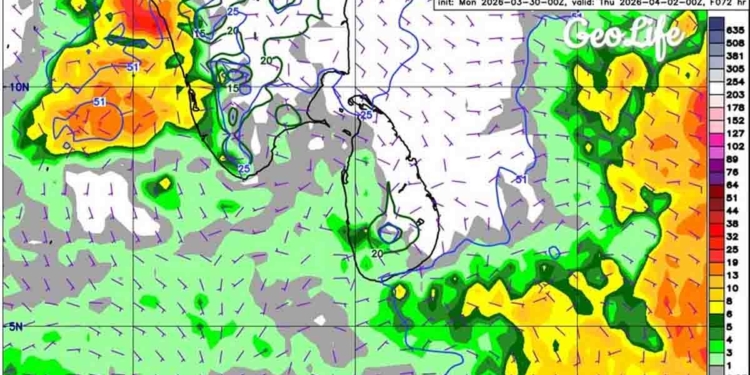
❄️ Model: ECMWF
❄️ Sri Lanka Time: Until 05:30 AM on Thursday, April 02, 2026 (based on UTC +5:30)
Key Observations
🌧️ Rainfall Pattern
According to the color scale on the map, varying levels of rainfall can be expected across different parts of Sri Lanka.
Southwestern and Central Areas
From the southwestern coastal belt to the central highlands, light rainfall ranging from 1 mm to 10 mm (light green zones) is observed.
Heavy Rainfall Zones
Areas west of Sri Lanka in the Arabian Sea and east in the Bay of Bengal show strong rainfall zones (orange and red areas) exceeding 25–50 mm.
🌬️ Wind Behavior
Purple short lines indicate wind direction and speed at a height of 10 meters. To the north of Sri Lanka, winds mainly blow from the northeast, while in the south they tend to blow from the west or northwest. This reflects a variation in atmospheric pressure.
🌐 Atmospheric Moisture and Pressure
Blue lines on the map represent the total atmospheric moisture.
Green lines indicate near-surface humidity, which remains around the 20 mm level in the central parts of the island.
By the early hours of April 02, 2026, although somewhat active rainfall conditions are present in the surrounding sea areas of Sri Lanka, the risk of severe flooding within the island remains low. However, light showers may occur in the southwestern and central regions, and it is important to stay alert to the possibility of rainfall systems over the sea moving inland.


