Afghanistan has once again dominated the front pages of Indian newspapers for five key reasons, each reflecting the evolving contours of India’s regional strategy and geopolitical engagements.
First, the Ministry of External Affairs (MEA) has initiated negotiations with a regime it does not officially recognise, thereby blurring the line between de facto and de jure diplomacy. Although India has resumed aid on a smaller scale, the message is unmistakable — New Delhi is increasingly willing to view its foreign relations through the pragmatic lens of realpolitik.
Second, the spirited women of the Indian press corps achieved what official diplomacy could not. They made headlines by forcefully entering a Taliban press conference and posing bold, uncompromising questions, setting an example of fearless journalism.
Third, attention turned to the visit of a Taliban delegation to the Islamic seminary of Deoband in Saharanpur — an institution they cite as a source of ideological inspiration. The delegation received a tumultuous welcome from locals, a stark contrast to the diplomatic formalities witnessed at venues like Hyderabad House or FICCI headquarters in New Delhi.
Fourth, the timing of the visit coincided with fierce clashes between Afghanistan and Pakistan, shattering the long-held myth of Islamic Ummah unity. Commentators in Islamabad were quick to attribute this rift to the emerging friendship between India and Afghanistan.
Finally, a fascinating geopolitical convergence has emerged. Russia, China, India, and Pakistan now find themselves aligned in opposition to the U.S. initiative to station troops at Afghanistan’s Bagram base — a move widely regarded as a strategic miscalculation made by Washington in 2021.
India’s 106-Kilometre Border with Afghanistan
This discussion, however, pivots to a lesser-known but equally significant subject — India’s 106-kilometre border with Afghanistan.
According to the First Schedule of Article 1 of the Indian Constitution, which defines the country’s territory, India shares a 15,107-kilometre boundary with seven nations.
The Border Management Division of the Ministry of Home Affairs (MHA) describes Afghanistan as the neighbour sharing the shortest boundary with India — adjoining the Union Territory of Ladakh. By comparison, India’s longest border stretches 4,097 kilometres with Bangladesh, followed by 3,488 kilometres with China, and 3,323 kilometres with Pakistan. The frontiers with Nepal and Myanmar extend 1,751 kilometres and 1,643 kilometres, respectively, while the border with Bhutan covers 699 kilometres.
The Contiguous Neighbourhood
While the notion of a contiguous neighbourhood had always been accepted, it was not explicitly reinforced until Home Minister Amit Shah’s 2019 statement on the Citizenship Amendment Act (CAA), which granted citizenship rights to Hindus and Sikhs from Afghanistan. India’s earlier reluctance to advocate for Afghanistan’s inclusion as a founding member of SAARC in 1985 was a missed diplomatic opportunity — later corrected in 2007 during the 14th SAARC Summit held in New Delhi.
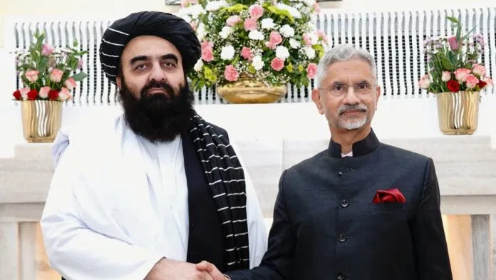
In this light, the recent joint statement issued by India’s External Affairs Minister S. Jaishankar and Afghanistan’s Amir Khan Muttaqi — acknowledging Wakhan as their contiguous neighbourhood — gains special importance. It also revives focus on the Gilgit-Baltistan region, over which India maintains territorial claims, as it was historically part of the princely state of Jammu & Kashmir, which acceded to India on October 26–27, 1947.
Before accession, the official title of the princely state was Riyasat-e-Jammu-wa-Kashmir-wa-Ladakh-wa-Tibet Ha (The State of Jammu, Kashmir, Ladakh, and Tibet). Gilgit-Baltistan was part of the Ladakh district and, due to its strategic significance, had been leased to the British Government of India for direct administration under the Viceroy.
Following the Indian Independence Act of June 1947, the area was returned to Maharaja Hari Singh on July 29, 1947. By August 1, the British flag was lowered, and Brigadier Ghansara Singh, a Dogra general, was appointed Governor of Gilgit-Baltistan. However, soon after the state’s accession to India, Major William Alexander Brown, then Commanding Officer of the Gilgit Scouts, mutinied alongside Muslim officers and surrounded the Governor’s residence — replacing the Indian flag with Pakistan’s.
Two days later, on November 3, Brigadier Singh and Colonel Abdul Majid Khan of the JAK Infantry were placed under house arrest. The mutiny, reportedly supported by elements within the British Army, was later rewarded — Major Brown received the Member of the Order of the British Empire (MBE) in February 1948. By that time, Pakistan had appointed its own military governor and formally integrated the area into Pakistan-occupied Jammu and Kashmir (PoJK). In 1994, Brown was posthumously awarded the Sitara-e-Pakistan (Star of Pakistan).
The Wakhan Corridor: Geography and Geopolitics
The Wakhan Corridor, a strategically critical strip of land in Afghanistan’s Badakhshan province, borders Gilgit-Baltistan (under PoJK) and Khyber Pakhtunkhwa (the former NWFP). Its 75-kilometre eastern boundary connects to China’s Xinjiang province — once part of the ancient Silk Road that linked China with Central Asia, Europe, and South Asia through Afghanistan.
The corridor stretches approximately 350 kilometres in length and varies between 20 and 60 kilometres in width, covering an area of about 10,300 square kilometres. Its rugged terrain and limited accessibility make travel difficult, with the main pass running through near-impassable mountains east of the Little Pamir. Around 18,000 residents inhabit 110 small villages scattered across this remote region.
Tensions have recently arisen between the Taliban and China, as Pakistan grows uneasy over Beijing’s expanding influence in Wakhan. China has reportedly slowed its Belt and Road Initiative (BRI) activities in the area to appease Pakistan — a country with which it boasts ties described as “higher than the mountains, deeper than the oceans, and sweeter than honey.”
Changing Demographics in Gilgit-Baltistan
Unlike in Jammu & Kashmir or Ladakh, Pakistan has pursued a deliberate policy to alter the demographic structure of Gilgit-Baltistan — generating deep resentment among locals. According to a recent publication by the Centre for Joint Warfare Studies in New Delhi, the outsider-to-insider population ratio in Gilgit-Baltistan stands at 3.5:4. By the end of this decade, the Punjabi and Muhajir communities — predominantly Sunni — are projected to form the majority.
This shift not only marginalises the indigenous population economically and politically but also poses strategic challenges for India. Following the reorganisation of Jammu & Kashmir into the Union Territories of J&K and Ladakh, 24 of the 114 seats in the J&K Assembly were reserved for residents of PoJK and Gilgit-Baltistan. Should Ladakh be granted a Legislative Assembly in the future, these seats should ideally be transferred to it, since Gilgit was historically a subdivision of Ladakh.
Strategic Interests Above Ideological Alignments
Opinions may differ on whether India should actively engage with the dynamics in PoJK and Gilgit-Baltistan, given the demographic changes and geopolitical sensitivities. However, it remains imperative that India maintains a clear understanding of the strategic implications of sharing borders — however short — with nations like Afghanistan.
Diplomacy must be guided by national interest rather than ideological sentiment. As British statesman Lord Palmerston aptly declared in the House of Lords in 1855:
“We have no eternal allies, and we have no perpetual enemies. Our interests are eternal and perpetual, and those interests it is our duty to follow.”


