
The low-pressure area in the Central parts of south Bay of Bengal moved west-northwestwards and concentrated into a depression, lay centered at latitude 10.0N and longitude 85.5E about 600km east of Jaffna. It is very likely to move toward Tamilnadu-Puducherry coasts during the next 48 hours. Therefore, Naval and fishing communities are advised not to venture into the deep and shallow sea areas off the coast extending from Kankasanturai to Batticaloa via Trincomalee and the southwest Bay of Bengal sea area for the next 24 hours.
Condition of Rain:
Showers or thundershowers will occur at several places in the deep-sea areas off the coast extending from Kankasanturai to Batticaloa via Trincomalee.
Winds:
Winds will be northerly and speed will be (25-35) kmph. Wind speed may increase up to (50-60) kmph at times in the sea areas off the coast extending from Kankasanturai to Pottuvil via Trincomalee and Batticaloa. Wind speed may increase up to 45 kmph at times in the other sea areas around the island.
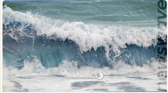
State of Sea:
The sea areas off the coast extending from Kankasanturai to Pottuvil via Trincomalee and Batticaloa will be rough at times. The other sea areas around the island will be fairly rough at times.There is a possibility that near shore sea areas off the coast extending from Kankasanturai to Pottuvil via Trincomalee and Batticaloa may experience surges due to the effect of swell waves, having (2.0-3.0) m height.
(curtesy News wave)